Wednesday, September 7, 2011
2011 Missouri River Flooding Update - Wednesday September 7, 2011
Receding water from the flooded Missouri River is revealing damage along its path.

Fort Calhoun nuclear power plant 20 miles south of Omaha gets safety downgrade

Posted: Tuesday, September 6, 2011 3:47 pmIn its latest review by the Nuclear Regulatory Commission, the Fort Calhoun Nuclear Station's performance was downgraded a notch and plans are in place for more inspection and oversight.
On the basis of two violations, the NRC placed the Fort Calhoun plant in the "Multiple/Repetitive Degraded Cornerstone Column," the second worst of five columns on its complicated Reactor Oversight Process Action Matrix. The only column lower is "unacceptable" and plants in that category are not allowed to operate.
Army Corps of Engineers predicts the Missouri River will return to normal levels in Nebraska, Iowa and Missouri sometime in October
AP OMAHA - September 7, 2011 — The Army Corps of Engineers predicts the Missouri River will return to normal levels in Nebraska, Iowa and Missouri sometime in October, and put an end to flooding that began in June.
The Corps' Jody Farhat said Tuesday the plan to gradually reduce the amount of water released into the river has been going well so far.
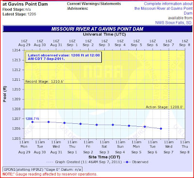
The Corps already cut the amount released from Gavins Point Dam in South Dakota from 160,000 to 90,000 cubic feet per second. Officials will wait until Sept. 16 to resume reductions, so there's time to check levees and make sure they're stable.
The Corps estimates that 37.5 million acre feet of water flowed down the Missouri River from May to August. That's significantly more than the normal runoff of 24.8 million acre feet.
http://journalstar.com/ap/state/article_5bfe5105-d838-57ad-9f39-93260dfdcd7b.html
SIOUX CITY IA - MISSOURI RIVER WATER LEVEL DROPS TO BELOW FLOODING STAGE - Sep 7, 2011
 http://siouxcityjournal.com/news/state-and-regional/south-dakota/article_601486e8-d960-11e0-8192-001cc4c002e0.html
NEBRASKA NUCLEAR POWER PLANTS NEXT TO FLOODING MISSOURI RIVER:

RadiationNetwork.com


Missouri River Dams and River Levels Flood Map
 http://www.mappingsupport.com/p/gmap4.php?q=https://sites.google.com/site/gmap4files/p/news/missouri_river.txt&ll=43.761599,-101.071993&t=h&z=6&label=on
US ARMY CORPS OF ENGINEERS FORECAST SCHEDULE OF RELEASES OF 6 MAINSTEM MISSOURI BASIN DAMS
Updated Daily
NOAA Hydrologic

http://water.weather.gov/ahps2/river.php?wfo=abr&wfoid=18696&riverid=203276&view=1%2C1%2C1%2C1%2C1%2C1%2C1%2C1&toggles=10%2C7%2C8%2C2%2C9%2C15%2C6&pt[]=145640&pt[]=142853&pt[]=144098&pt[]=144183&pt[]=142396&pt[]=143355&allpoints=143990%2C145585%2C145025%2C145026%2C144876%2C145027%2C143234%2C143184%2C145519%2C145640%2C144217%2C142150%2C142780%2C142853%2C145202%2C141586%2C144582%2C143543%2C144796%2C144098%2C144240%2C141320%2C141614%2C142968%2C144183%2C142574%2C143478%2C142193%2C142760%2C142003%2C142610%2C142396%2C144496%2C147345%2C141899%2C143355%2C142050%2C141570%2C144165%2C143476%2C141703%2C142023%2C144123%2C141863%2C143539%2C143436%2C141917%2C143009%2C142688%2C142640%2C143925%2C143734%2C142729%2C143790%2C142668%2C141962%2C142132&data[]=hydrograph&submit=Make+my+River+Page!

GARRISON DAM - NORTH DAKOTA

FT RANDALL DAM - NEAR CHAMBERLAIN SD

GAVINS POINT DAM - NEAR YANKTON SD

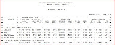
RESERVOIR CONTROL CENTER REPORTS
Link to daily report:
- The Cave's Archive of daily NW DIVISION OF THE US ARMY CORPS OF ENGINEERS RESERVOIR CONTROL CENTER DAILY REPORT
- The Cave's OVERFLOW website focused upon US Army Corp of Engineer's Mismanagement of the 6 Missouri River Basin Dams
- THE CAVE'S OVERFLOW - Archive of the Cave's Daily Flood of 2011 Updates


0 comments:
Post a Comment