Wednesday, July 25, 2012
We're Your Government, And We're Here To Help
Read more: http://www.kfab.com/pages/voorhees.html#ixzz21d1tyfjS
Read more...
Wednesday, September 7, 2011
2011 Missouri River Flooding Update - Wednesday September 7, 2011
Receding water from the flooded Missouri River is revealing damage along its path.

Fort Calhoun nuclear power plant 20 miles south of Omaha gets safety downgrade

Posted: Tuesday, September 6, 2011 3:47 pmIn its latest review by the Nuclear Regulatory Commission, the Fort Calhoun Nuclear Station's performance was downgraded a notch and plans are in place for more inspection and oversight.
On the basis of two violations, the NRC placed the Fort Calhoun plant in the "Multiple/Repetitive Degraded Cornerstone Column," the second worst of five columns on its complicated Reactor Oversight Process Action Matrix. The only column lower is "unacceptable" and plants in that category are not allowed to operate.
Army Corps of Engineers predicts the Missouri River will return to normal levels in Nebraska, Iowa and Missouri sometime in October
AP OMAHA - September 7, 2011 — The Army Corps of Engineers predicts the Missouri River will return to normal levels in Nebraska, Iowa and Missouri sometime in October, and put an end to flooding that began in June.
The Corps' Jody Farhat said Tuesday the plan to gradually reduce the amount of water released into the river has been going well so far.
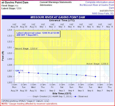
The Corps already cut the amount released from Gavins Point Dam in South Dakota from 160,000 to 90,000 cubic feet per second. Officials will wait until Sept. 16 to resume reductions, so there's time to check levees and make sure they're stable.
The Corps estimates that 37.5 million acre feet of water flowed down the Missouri River from May to August. That's significantly more than the normal runoff of 24.8 million acre feet.
http://journalstar.com/ap/state/article_5bfe5105-d838-57ad-9f39-93260dfdcd7b.html
SIOUX CITY IA - MISSOURI RIVER WATER LEVEL DROPS TO BELOW FLOODING STAGE - Sep 7, 2011
 http://siouxcityjournal.com/news/state-and-regional/south-dakota/article_601486e8-d960-11e0-8192-001cc4c002e0.html
NEBRASKA NUCLEAR POWER PLANTS NEXT TO FLOODING MISSOURI RIVER:

RadiationNetwork.com


Missouri River Dams and River Levels Flood Map
 http://www.mappingsupport.com/p/gmap4.php?q=https://sites.google.com/site/gmap4files/p/news/missouri_river.txt&ll=43.761599,-101.071993&t=h&z=6&label=on
US ARMY CORPS OF ENGINEERS FORECAST SCHEDULE OF RELEASES OF 6 MAINSTEM MISSOURI BASIN DAMS
Updated Daily
NOAA Hydrologic

http://water.weather.gov/ahps2/river.php?wfo=abr&wfoid=18696&riverid=203276&view=1%2C1%2C1%2C1%2C1%2C1%2C1%2C1&toggles=10%2C7%2C8%2C2%2C9%2C15%2C6&pt[]=145640&pt[]=142853&pt[]=144098&pt[]=144183&pt[]=142396&pt[]=143355&allpoints=143990%2C145585%2C145025%2C145026%2C144876%2C145027%2C143234%2C143184%2C145519%2C145640%2C144217%2C142150%2C142780%2C142853%2C145202%2C141586%2C144582%2C143543%2C144796%2C144098%2C144240%2C141320%2C141614%2C142968%2C144183%2C142574%2C143478%2C142193%2C142760%2C142003%2C142610%2C142396%2C144496%2C147345%2C141899%2C143355%2C142050%2C141570%2C144165%2C143476%2C141703%2C142023%2C144123%2C141863%2C143539%2C143436%2C141917%2C143009%2C142688%2C142640%2C143925%2C143734%2C142729%2C143790%2C142668%2C141962%2C142132&data[]=hydrograph&submit=Make+my+River+Page!

GARRISON DAM - NORTH DAKOTA

FT RANDALL DAM - NEAR CHAMBERLAIN SD

GAVINS POINT DAM - NEAR YANKTON SD

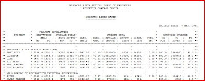
RESERVOIR CONTROL CENTER REPORTS
Link to daily report:
- The Cave's Archive of daily NW DIVISION OF THE US ARMY CORPS OF ENGINEERS RESERVOIR CONTROL CENTER DAILY REPORT
- The Cave's OVERFLOW website focused upon US Army Corp of Engineer's Mismanagement of the 6 Missouri River Basin Dams
- THE CAVE'S OVERFLOW - Archive of the Cave's Daily Flood of 2011 Updates
Read more...
Sunday, September 4, 2011
Wednesday, August 31, 2011
Tuesday, August 30, 2011
(AP) - Ft. Calhoun the NE nuclear power plant that was entirely surrounded by Missouri River floodwaters no longer in flood emergency

http://bismarcktribune.com/news/state-and-regional/neb-nuclear-plant-no-longer-in-flood-emergency/article_036db1da-d2c6-11e0-b445-001cc4c03286.html
Monday, August 22, 2011
2011 MISSOURI RIVER FLOODING - AUGUST 22, 2011
Search Results
Beyond control: In 2011, the Missouri River foiled all efforts to ...
Bismarck Tribune - Tom Stromme - 1 day agoMike Odegaard reflects on the experience of successfully saving his Hoge Island home from the 2011 Missouri River flood. Since 1954, the Garrison Dam has ...Nixon attends Nebraska governors meeting, says cooperation needed ... Missourinet.com
ND officials: Missouri River flood warnings late KCAU
ND officials: Missouri River flood warnings late Rapid City Journal
all 33 news articles »Governors request Missouri River flood-plan update
San Francisco Chronicle - 2 days agoAP Nati Harnik / AP Governors from Missouri River states hold a news conference in Omaha, Neb., Friday, Aug. 19, 2011, following their meeting to discuss ...Governors say flood control must be priority on Missouri River Reuters
Missouri River governors discussing plans to avert repeat of this ... Washington Post
Congressman King joins media for a first hand tour of Missouri ... KTIV
NPR - Missourinet.com
all 1049 news articles »Notes: Boat traffic still limited by flooding
Omaha World-Herald - 6 hours agoHAMBURG, Iowa — The Missouri River remains closed to boat traffic due to ongoing flooding, although outflow from the federal dams upriver is gradually being ...2011 Ties for Most Billion-Dollar Weather Disasters
Our Amazing Planet - Brett Israel - 3 days agoNumerous levees were breached along the Missouri River, flooding thousands of acres of farmland. The flooding, which is ongoing, has caused more than $2 ...2011 set to become worst ever year for US weather disasters Daily Mail
In 2011, record-tying nine $1B weather disasters USA Today
Year Packed With Weather Disasters Has Brought Economic Toll to Match Ocala
msnbc.com
all 201 news articles »Five Flood Facts from the Army Corps of Engineers
KTIV - Kyle Martens - 4 days agoThe US Army Corps of Engineers, Missouri River Joint Information Center, ... the 2011 Flood and whether additional flood control storage is necessary. ...Water output at Gavins Point to slowly ease down Radio Iowa
Corps problem: Many demand Southeast Missouri levees rebuilt to 62 ... Southeast Missourian
Missouri reservoirs out of flood control zone Rapid City Journal
STLtoday.com - News-Press Now
all 63 news articles »Five Flood Facts (IV): A Focus on the 2011 Missouri River Basin Flood
Syracuse Journal-Democrat - Aug 11, 20112011 will be a new point in the history of the Missouri River Basin, both in terms of hydrology and flood plain impacts. The Corps will review the flooding ...Dam releases cut, river falling below 17 feet Bismarck Tribune
Two-day delay on change to Missouri River releases Blue Springs Examiner
all 10 news articles »Corps: Ft. Randall Dam Needs More Repair
Yankton Daily Press - Randy Dockendorf - 6 days agoPICKSTOWN — Fort Randall Dam remains structurally sound, but more repair work may be needed once the Missouri River flood waters recede, ...Missouri River Still Closed To Boat Traffic In Siouxland
KCAU - 2 days agoThese relaxed fishing regulations for isolated water bodies in Missouri River flood plain in Iowa will remain in effect until on or about November 30, 2011. ...'There's just zero availability' Bismarck Tribune
all 18 news articles »2011 ties record for most billion dollar weather disasters
Washington Post (blog) - Jason Samenow - Jul 26, 2011Billion dollar weather events in the US during 2011. Count indicated by size of bars (adapted by author to include Missouri River flooding ...Flood tracker for July 27, 2011 Blue Springs Examiner
Dalrymple says corps must give answers Bismarck Tribune
ND gov. wants corps to address flooding questions Devil's Lake Daily Journal
all 49 news articles »Regulations will be relaxed on fishing holes created by Missouri ...
Radio Iowa - Dar Danielson - Aug 10, 2011The Missouri River flowed out of its banks in ... washed out in the Saylorville area after the flooding there in 2008. ...


